- Trailhead
- Trip Reports
- Photo Essays
- Map of Hikes
- Hike Calculator
- List of Links
- Why I Hike
- Mountain Towns
- Warning
- Misc. Photos
- Photo Credits
- F A Q
Please click on the mountain images at the top or bottom of the page to navigate this site. Sorry for this temporary inconvenience.
Starting Elevation:
~ 10,121 feet
Highest Elevation:
11,906 feet
Distance (round trip):
~ 10 miles ?
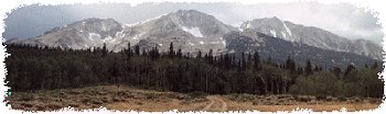
Even though this was a midweek hike, the parking lot at the trailhead was almost full. This is an easy yet beautiful hike that takes you to the top of the Continental Divide. This trail begins by following several switch-backs through a beautiful forest on a south facing slope. We crossed several avalanche chutes on the way up from the parking area to tree line. At tree line we found the remains of an old mine and the trailhead to South Arapaho Peak and Arapaho Glacier.
From this point, we continued west along a gradual traverse of a mile or so. As we gained elevation, the vastness of the valley unfolded as we discovered that we were surrounded (except to the east) by several massive, sharp, rugged peaks including Mt. Neva and South Arapaho Peak.
It was extremely windy on the pass so we headed further west (and slightly higher) where we found Lake Dorothy. This was a beautiful lake tucked away high at the base of several peaks. The snow fields, boulders, and sub-peaks around the lake really make you feel as though you have just landed on some distant, surreal planet.
After exploring the area around the lake we found the hike back down to be easy. We just retraced our steps all of the way back to the car.
Along on this hike with me: Korrie.