Please click on the mountain images at the top or bottom of the page to navigate this site. Sorry for this temporary inconvenience.
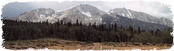
Hidden within the steep walls of Glenwood Canyon on Interstate 70 about 150 miles west of Denver and 7 miles east of Glenwood Springs, Colorado lies a popular and relatively easy hike up a side canyon to a beautiful lake and two waterfalls.
Important Notes
- Fishing is NOT allowed at the lake.
- Dogs are NOT allowed on the trail.
The trailhead can be somewhat tricky to find now that the Interstate highway bypasses part of the canyon by going through the Hanging Lake Tunnel. One can only get to the trailhead when heading eastbound on I-70. This means that if you are traveling westbound on I-70 you must actually pass Hanging Lake (while in the tunnel) and exit at the Grizzly Creek rest area (and trailhead) several miles to the west. At Grizzly Creek, exit the highway, turn left and immediately turn left again so that you are now on the on ramp to I-70 eastbound. Pass the exit to Shoshone and several miles later you will get off the highway at the exit marked Hanging Lake (just before you would enter the tunnel - eastbound - if you had not left the highway). The parking area is well taken care of as it serves a dual purpose of rest area and trailhead.
The parking area sits in the bottom of the canyon along the banks of the Colorado River several hundred feet upstream from the Shoshone Dam. This dam diverts a portion of the Colorado River through a tunnel in the mountain to the Shoshone Power Plant several miles downstream. Several months of the year (winter) just below the dam, one could cross the Colorado River literally by stepping and jumping from rock to rock however during the spring runoff river roars through the channel creating water that is unnavigable by any sort of white water craft (that I've ever seen or heard of - and I used to be a local).

The Amphitheater with I-70 in the distance.
From the parking area the first quarter mile or so of the hike is really just a walk along the bike path that runs the length of Glenwood Canyon. Although mostly courteous, bicyclists and in-line skaters heavily utilize the bike path - please allow them plenty of room. By the way, the rock you see with the cable on it (you'll know what I mean after you visit) is called Anchor Rock - see if you can figure out why? After following the river upstream (East) you will reach a bend where the canyon turns south. This is where the old trailhead to Hanging Lake was located before the Interstate highway was completed. Here you will find more "comfort facilities" and several picnic tables both near where Deadhorse Creek meets the Colorado River and tucked into the trees as well. Be sure to look to your south (upriver) to see a massive Amphitheater which was carved by the river over tens of thousands of years.

The rocky first steps of the hike.
Ready? Now that we are at the trailhead it is now time to climb to Hanging Lake. Although I am not sure of any distances or elevation gains (I'll check the next time I'm there), the sign at the trailhead suggests that it will take the average visitor about an hour to get up to the lake and about the same to get down. The trail follows a side canyon on the north side of Glenwood Canyon. It begins by taking you up and across what most tourist think is a steep talus slope however due to the popularity of the trail and frequent maintenance by the Forest Service and Boy Scouts your footing will be good with steps carved into the rocks in the more difficult areas.
After about 150 yards up the rock slope you suddenly are covered by a canopy of trees. During the summer you will feel a cooling effect from the shade while other times of the year this area can appear quite different. Next you may see (most people miss it) the sign to Deadhorse Trail on your right. I wouldn't suggest taking this trail (it doesn't go to Hanging Lake) unless you are ready for a steep climb towards the top of the canyon and the meadows above. Stay on the main trail and you may notice that it has leveled off a bit. This trail continues to wind up the canyon while crossing the creek 5 (or 6?) times on well maintained wooden bridges. There will be some spots that are steeper than others but benches have been provided several places along the trail to aid the winded hiker.

Looking back down on the railings as seen from the top.
Now that you are out of breath and beginning to wonder if you will ever get there you will notice that the canyon has slightly widened. You make a sharp right turn and begin to follow the canyon wall (now on your left). As you begin to climb you will have a hand railing on your right for stability. After about a hundred feet (distance - not vertical) you are no longer on a trail per se but climbing steps (as high as a foot and a half) carved into the rock with the railing still available for assistance should you feel the need. This is the steepest part of the entire hike however you really only climb about 45 feet vertically and have a solid railing for the entire time. Where's the lake?

Left to Spouting Rock - Right to Hanging Lake.
Once you have made it to what appears to be the top you will find yourself standing on a boardwalk (provided by the Boy Scouts). Follow the boardwalk to the right and suddenly before you will be one of the most crystal clear lakes colored hues of blue, green, and aquamarine that you will ever see! You can just as easily see trout swimming in the water twenty feet out and 6 feet down as you can follow the dead tree lying in the lake to where it disappears somewhere deep below. The boardwalk follows the South side of the lake just above a marshy outlet. Along the boardwalk there are two "places" where you can stand and look across the lake at the waterfall which is the source of this beauty. Walk the boardwalk to the end you will know why they call it Hanging Lake. Don't forget to look back down the canyon as there is quite a view to your south.

Hanging Lake
Before leaving Hanging Lake you will want to visit Spouting Rock. As you head back towards "the steep part" you will see a sign for Spouting Rock on your right. Follow this short trail up the steep slope to the next level above Hanging Lake and you will be rewarded with a waterfall spouting directly from the face of a cliff! Below the waterfall is a shallow "cave" which was created through the erosionary forces of the back-splash of the waterfall. The extra distance is probably only a few hundred yards and the area surrounding the runoff from the waterfall (which feeds Hanging Lake) has a magical/mystical charm. In the winter and early spring Spouting Rock produces a hollow ice stalagmite-like caldera. I have seen these ice cones as tall as 70 feet or more! Later in the spring during runoff Spouting Rock can be somewhat hidden as the capacity of the channel through the rock is not great enough for all of the water coming off the mountains. This creates a waterfall coming off the cliff above Spouting Rock. Later in summer just standing near the back-splash from the waterfall is enough to cool one off.
Your trip back down retraces your trip up. Novice hikers might automatically assume that this means that the going is easy from here on out - however this is not always the case. You will be working a different group of muscles on your way down while you try to keep from gaining momentum (thanks to gravity). While you ponder your accomplishment and wonder at the beauty surrounding you, don't hesitate to stop to chat with the other hikers on their way up. The tourists will invariably ask you "How much further?" When this happens be sure to remember the locals response "You're almost there".
If you see a guy running down the trail with Rollerblades hanging from his pack, please don't bother to stop me to ask "How much further?" |
Along on this hike with me: Too many different people to list.