Trailhead
Trip Reports
Photo Essays
Map of Hikes
Hike Calculator
List of Links
Why I Hike
Echo
Mountain Towns
Warning
Misc. Photos
Photo Credits
F A Q


Please click on the mountain images at the top or bottom of the page to navigate this site. Sorry for this temporary inconvenience.
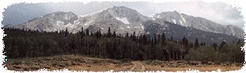
Unnamed Valley

near La Plata Peak
August 22, 1999
San Isabel National Forest
Collegiate Peaks Wilderness
Starting Elevation:
10,440 feet
Highest Elevation:
12,749 feet
Distance (round trip):
8 miles
click on each photo to view a larger image
The unnamed valley in this hike is also known as being the first part of the hike to the summit of La Plata Peak. If you can find the historic town of Winfield, Colorado nestled in the Clear Creek Valley (how many of those are there in this state?) in the Collegiate Peaks, you can easily find this hike.

To get to the hike from Winfield, take a right turn in town (you can only go right or left) and head up towards the Winfield Cemetary about 3 tenths of a mile up the road. Park near here if you're in a car, or if you're in a 4WD you can drive the additional 2 miles to the trailhead which is somewhat hidden another 2 tenths of a mile off of another off-road track north of the main 4WD road.
The historic town of Winfield,  Colorado.
The historic town of Winfield, Colorado.
I parked my non-four wheel drive vehicle near the Winfield Cemetary.
The last two maintained grave sites belong to the Aude family.
The 4 x 4 road into the North Fork of the Clear Creek valley.  The unnamed valley is up and to the right (north) in this photo.
The 4 x 4 road into the North Fork of the Clear Creek valley. The unnamed valley is up and to the right (north) in this photo.
From the saddle between La Plata Gulch and the unnamed valley there was an incredible view of some jagged cliffs off to the east-northeast and an unnamed summit of 13,686 feet.
Mount Champion (13,646 feet) provides a centerpiece to the view to the north from the saddle.
Again from the saddle, looking northeast up the ridge towards the summit of La Plata Peak (not visible).
Sayers (13,738 feet) off to the southwest of the saddle.
The ridge which defines the west wall of the La Plata Gulch.
From left to right, Brown's Peak (13,523 feet), Huron Peak (14,003 feet) and the Three Apostles.  Winfield Peak (13,077 feet) and Virginia Peak (13,088 feet) are one valley closer on the right.
From left to right, Brown's Peak (13,523 feet), Huron Peak (14,003 feet) and the Three Apostles. Winfield Peak (13,077 feet) and Virginia Peak (13,088 feet) are one valley closer on the right.
A wider view of the same shot above looking into the interior of the Collegiate Peaks.
Rusting rails lead to the entrance of an abandoned mine high up on the mountain.
The view of the jagged cliffs to the east-northeast of the unnamed valley.
Timer photo of myself.
Looking north up the valley through the ruins of an old mining shack.
Winfield Peak (13,077 feet) as seen through the ruins of an old mining shack (looking south-southeast).
Again, looking north up the valley - this time from the middle of a lush creek.
Along on this hike with me: no one.