Trailhead
Trip Reports
Photo Essays
Map of Hikes
Hike Calculator
List of Links
Why I Hike
Echo
Mountain Towns
Warning
Misc. Photos
Photo Credits
F A Q


Please click on the mountain images at the top or bottom of the page to navigate this site. Sorry for this temporary inconvenience.

Mount Sheridan

June 8, 2000
San Isabel National Forest
Starting Elevation:
12,25X feet
Highest Elevation:
13,748 feet
Distance (round trip):
4 1/2 miles
click on each photo to view a larger image
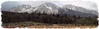
Just east of the town of Leadville, Colorado, lay Mount Sheridan as well as several other easily climbable peaks including Mount Sherman. Although it can be a little tricky finding the correct road, from the historic marker on the south end of town, head east up just about any of the city streets and after 3 blocks, turn right, which will put you on a road which takes you southeast. Continue on this road past some old mining tailings ponds and on towards the historic site of Oro City (about 2 1/2 miles from town). After winding around several drainages and driving several more miles you will need to turn left on a poorly marked gravel road which heads up the hill and into Iowa Gulch. As this road is not marked very well, if you end up at a dead end at the Hellena Mine, retrace your route and the road you seek will be the best maintained road shooting back off to your right. If you don't miss the turn off your total drive from Leadville to where the hike begins will be about 7 3/4 miles.
Mount Sheridan is the tall one on the right.
This is more like what Mount Sheridan looks like from where the hike begins.
Horseshoe Mountain (13,989 feet) is about 1.6 miles south of the summit.
Although I had already walked past this, the actual summit of Mount Sheridan (13,748 feet), here's what it looks like when facing east with South Park as the background.
Only a few feet lower than the actual summit, on the west side of the top of the mountain there exists stone structure which I used to block the wind.
About 1.4 miles northeast of the summit of Mount Sheridan lies the summit of Mount Sherman (14,036 feet).  Note the trail scars on the southwest face of Sherman.
About 1.4 miles northeast of the summit of Mount Sheridan lies the summit of Mount Sherman (14,036 feet). Note the trail scars on the southwest face of Sherman.
White Ridge (13,684 feet) to the east with South Park once again in the background.
A view of Iowa Amphitheater to the north-northeast which contains the currently closed Continental Chief Mine.  Surrounding the Amphitheater (from left to right) are Dyer Mountain (13,855 feet), Gemini Peak (13,981 feet) and Mount Sherman (14,036 feet).
A view of Iowa Amphitheater to the north-northeast which contains the currently closed Continental Chief Mine. Surrounding the Amphitheater (from left to right) are Dyer Mountain (13,855 feet), Gemini Peak (13,981 feet) and Mount Sherman (14,036 feet).
The view west-southwest from the summit includes Mount Elbert (14,433 feet) on the left and Mount Massive (14,421 feet) on the right.
Looking back on the saddle between Mount Sheridan and West Sheridan (12,962 feet) which completed my loop return back to where I began my hike.
Along on this hike with me: no one.