Trailhead
Trip Reports
Photo Essays
Map of Hikes
Hike Calculator
List of Links
Why I Hike
Echo
Mountain Towns
Warning
Misc. Photos
Photo Credits
F A Q


Please click on the mountain images at the top or bottom of the page to navigate this site. Sorry for this temporary inconvenience.

St. Mary's Glacier

Late Summer, 1998
Arapaho National Forest
Starting Elevation:
10,300 feet ?
Highest Elevation:
11,XXX feet
Distance (round trip):
1 mile
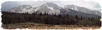
click on each photo to view a larger image
Getting There: Take I-70 West from Denver, past the town and three exits of Idaho Springs. Take the next exit marked "Fall River Road". Just past the bottom of the ramp, take a right (north) on Fall River Road. Follow this road up past the town of Alice to one of two parking areas for the clearly marked trailhead to St. Mary's Glacier.

Did You Know? The only place in the United States (world?) where a river flows into a creek is by where you exit I-70 to head up towards St. Mary's Glacier. Near this intersection, Fall River flows into Clear Creek!

Here is some good information I received from a local resident of the area via email:

Your info and pictures are great. I only wish to inform you and all who read your sight, some facts of the area.

First, the two mentioned parking area's are private property. I own the smaller of the two. These "parking area's, are sub-division lots.

Second, all the land below and immediately surrounding the glacier are also private property. The forest service has most of the land above the glacier.

Third, your picture with the jeep coming up the "road", not trail, was good. The trail hike is a sub-division road that is not developed yet. I doubt the driver was a property owner, but he was'nt tresspassing, until he stopped, and went on the hike. The community and the forest service made the road, rougher than it was to keep people from driving, cutting a trail with vehicle, to the glacier. In Colorado the law is you need to know where you are, or going, property owners don't have to post property signs.

I don't wish for the hike to be closed, I just wish people understood the area better. Most people are stewards to the area, pack in/pack out, keep dog's leashed at all times, bury their and their dog's "business", and I think the most important, STAY THE TRAIL.

I own 16 lots by the glacier and am constantly catching people, cutting of the trail and taking "short cuts". I always am nice, and remind people to go back the way you came. Most people are reasonable, but of course there are the people who try to ruin it for everyone.
The trailhead to the glacier.
... follow the closed road ...
St. Mary's Glacier from across the lake.
Avalanche territory in the winter.
Beauty at the lake.
Beauty at the lake.
The glacier as seen through the trees.
The trail around the lake towards the glacier.
Where glaciers end ...
closeup
closeup
Wild flowers, rock, and ice.
The view down valley.
What the surface looks like up close ...
... and the lake from above.
What's that vehicle doing up here?
Tresspassing, I guess.
Along on this hike with me: no one.