- Trailhead
- Trip Reports
- Photo Essays
- Map of Hikes
- Hike Calculator
- List of Links
- Why I Hike
- Mountain Towns
- Warning
- Misc. Photos
- Photo Credits
- F A Q
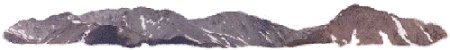
Please click on the mountain images at the top or bottom of the page to navigate this site. Sorry for this temporary inconvenience.
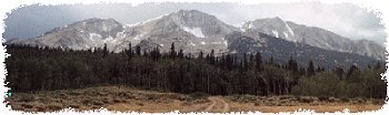
Starting Elevation:
9,8XX feet ?
Highest Elevation:
12,777 feet
Distance (round trip):
~ 5 miles
click on each photo to view a larger image
To reach the trailhead, exit I-70 at Dillon/Silverthorne (Exit 205) and head north to the first stoplight (not counting the one at the off-ramp). Turn left at this stoplight (by 7-11) and continue up this road past all of the Factory Outlet stores (...and you thought this was going to be a Wilderness experience) as it parallels the Interstate highway. Where this road makes its first switch back (by the convenience stores) I now consider myself to be in a condo-land called Wildernest. The road winds for about a mile through condo-land and near the top of the loop exists a parking area for two trailheads. The trailhead furthest west is called Lily Pad Trail. This is the wrong trail. Slightly east you will find another trailhead - this one is not named but can easily be found due to a sign-in register and another generic Forest Service bulletin board / sign.
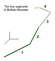 The easiest way for me to describe my trip to the summit of Buffalo Mountain is to break it down into 4 unique segments - each corresponding to unique hiking and terrain.
SEGMENT 1
This segment consists of a gentle climb through a coniferous forest where the trees create a roof so dense one might wonder if you would get wet during a shower. The trail itself is well worn and wide as this is a popular hiking trail for both locals and visitors to Summit County. I saw more squirrels on this segment of the hike than I have probably seen all summer! About a half of a mile into the hike the trail comes to what I consider to be a major back-country intersection. This was the equivalent of a Wilderness four-way stop. The sign indicated that my destination was to the left - so that's the way I went. About a quarter of a mile later my trail sort of dead-ended at the remnants of an old cabin - dilapidated to the point that only the bottom two or three rungs of logs were still intact.
SEGMENT 2
After crossing a downed tree which was blocking my way to the cabin I noticed a trail heading steep up the mountain. I briefly looked around for alternatives but this appeared to be the direction of my travel so I began my climb. The forest was still thick in this segment of the trail but by now I was heading up a slope about as steep as they come. There was lots of deadfall in the area but it wasn't so bad such that I didn't enjoy a quick rest while reflecting on how to get over or around the dead trees.
The forest began to thin out as I approached tree-line and I came upon another hiker on his way down. From our brief conversation I got the impression that once upon the rocks I needed to go to the right. More on that later. I would estimate that this segment of the hike was about a half mile in length and had allowed me to gain some serious elevation.
SEGMENT 3
As I climbed up and out of the forest I noticed that the trees ended abruptly at the edge of a large boulder field. There was red flagging marking where the trail entered the trees - both tied to a stick stuck in the rocks as well as tied high up in one of the trees. I shouldn't have any problem finding this trail on my way back down.
Looking up at the rocks in front of me I didn't see any other sort of markings - flagging, cairns, or otherwise - indicating which way I should go. I thought to myself, this must be where the other hiker meant I should go right. Due to limited visibility in that general direction - and the fact that what I could see looked like it could be somewhat treacherous - going right didn't seem like an option. To the left didn't look much better than what was in front of me, therefore I choose to go straight up the boulder field.
Once I had gotten well into the boulder field I knew that this was not the route that most people took to reach the summit of Buffalo Mountain. Nonetheless I persisted up and over both small and large rocks (boulders) - some stable - some not so stable. I thought to myself - If only I can reach that ridge (above me). After about a half an hour of scrambling up the boulders I saw to my left another hiker headed down the mountain on what must have been the actual trail. Oops! By now I was at the boulders that made up the ridge and I was able to pick my way through and up to the top of this mountain feature.
On top of this shoulder of the mountain I had a clear view hikers on the trail - several hundred yards to the west of my position. I also had a great view looking down on the rooftops of the condos in condo-land below.
SEGMENT 4
This segment begins the high alpine segment of the hike. No more scrambling on boulders and nowhere near as steep as the previous two segments. The summit was in sight and the walk to the top consisted mainly of your typical rock/dirt/earth surface. Due to the quantity of rocks, I found the hiking was easiest if I would plan my steps so that each foot would land on a rock - kind of like nature's stairway. Nearing the top I could see off the back-side of the mountain (north). From here it was quite a drop to the bottom of South Willow Creek. Although hiking here was basically flat, I still wasn't at the summit. Continuing to the top, the ridge narrowed to about ten feet wide with drop-offs on both the front and back side. There was one short portion along this ridge where I felt a little exposed while climbing down - and then up a ten foot (or so) notch in the mountain. Shortly after this notch I declared myself to be on the summit.
 Looking Southwest along the summit ridge.
 , Dillon / Silverthorne (left) and Dillon Reservoir.") Looking down on the towns of Frisco (right), Dillon / Silverthorne (left) and Dillon Reservoir.
Looking down on the towns of Frisco (right), Dillon / Silverthorne (left) and Dillon Reservoir. SEGMENT 4 - THE TRIP DOWN
As I was beginning to feel the clouds moving in around me I wanted to try to stay on the established trail to make time on my way back down. After leaving the relative flatness of the summit I saw a cairn marking the beginning of the trail. I followed the cairns until they lead me to a point just west of where my prior segment 3 turned into segment 4. As the weather had cleared somewhat I decided to take a break and enjoy my time on the mountain for as long as I could.
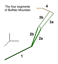 SEGMENT 3b
After my rest I traversed back to the established trail to begin my descent of segment 3b. Although on my way up segment 3a I wondered about my safety, I was now concerned for a different reason. The trail for segment 3b was not only steep but was so well worn that footing was haphazard at best! The mountain had been worn to dirt and in search of better footing, previous hikers had widened the path significantly. I wondered to myself how the Forest Service could control the erosion but other than a massive trail/stair building project I could offer no solution.
Having lost enough elevation I was about to once again enter the trees. The end of segment 3b / beginning of segment 2b was marked with red flagging but it wasn't the same red flagging that I had seen on the way up. I chose to traverse east about 200 feet where I found the flagging I had seen on my way up the mountain.
SEGMENT 2a/2b
I rationalized that since this was the way I came up, this was the way I should return (segment 2a). I wasn't sure where segment 2b went and wanted to make it back down in the shortest way possible. Upon reaching the dilapidated cabin (where my segment 1 turned into segment 2) I looked around for the beginning of segment 2b. Just downhill from the cabin I found another well worn trail that must have been the begining of segment 2b. All of the fallen trees and lack of maintenance on segment 2a told me that I should've been on segment 2a the entire time. Segment 2b is the way that I would recommend you follow on your way to the summit (although I never did travel on this segment myself). From the cabin it was an easy walk through the forest back to the trailhead and the car.
From now on, whenever I travel I-70 down from the tunnel into Summit County, I can look at Buffalo Mountain perched over the valley and say, "I did that one!"
Along on this hike with me: no one.