Please click on the mountain images at the top or bottom of the page to navigate this site. Sorry for this temporary inconvenience.
When a friend told me that they were thinking of making Grays Peak wheelchair accessible I thought she was kidding. It wasn't until I climbed this mountain that I realized that she was probably serious. If you are looking for a remote mountain experience with solitude, this is not the hike for you. If you are looking for what I'm calling "Interstate Highway" hiking then by all means select Grays and Torreys Peaks.
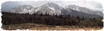
Grays and Torreys Peaks are two 14'ers that can be easily climbed in one day. Lying just south of Interstate 70 about 40 miles west of Denver these peaks are climbed by hundreds of hikers each weekend during the summer hiking season. Exit I-70 at the Bakerville Exit 221 and head for south for Stevens Gulch and Stevens Mine (4 miles) on a steep gravel road. Note: Four wheel drive is not required to reach the trailhead however autos will have to take their time to pick the best line up the road. At the end of this road you will find a parking area which will most likely be filled to capacity. This is where you will begin your wilderness adventure.

The trail was well maintained and heavily traveled.
From the parking area the trail crosses one bridge and begins a mild yet steady climb as it heads southeast towards your destination(s). For the first half mile or so I would consider the trail to be wheelchair accessible (with the possible exception of several steps, a stream crossing or two, and the grade of the trail). I mention this because of the extensive trail building and maintenance performed on this portion of this trail.

The trail continues to climb towards the summit of Grays Peak.
The trail continues its climb while meandering uphill via several long switch backs. Once at an elevation where you have lost practically all large vegetation the trail once again crosses Stevens Creek - this time without a bridge (but with plenty of rocks carefully placed for a dry crossing). Shortly thereafter the real climb begins. As you approach the first real switch back you notice how far the summits of Grays and Torreys appear to be. There must be more flat hiking ahead. Wrong! At the end of each switch back there may be a short level stretch however the switch backs just keep coming and coming and coming. Eventually you notice that you have passed the base of the mountain and are now on your way up. Switch back after switch back you continue to climb.

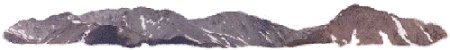
Looking back down the valley from well above treeline.
Although the main trail is wide, well maintained, and easily distinguishable you will notice that the weekend hikers have created dozens if not hundreds of short-cuts across the face of the mountain. [Note: Serious hikers / backpackers frown on using shortcuts as all trails destroy the natural environment - there is no need for additional trails]. As you are now well above 13,000 feet in elevation you will probably notice many other hikers resting every several hundred feet or so (distance - not vertical) along the trail. [Solitude?] You will notice a cut-off across the saddle to Torreys Peak (about 3/4 mile north of Grays) however I chose to bag Grays Peak first.

The crowd on the summit of Grays Peak.
Eventually after passing multitudes of resting hikers (including one that kept whistling for her lost off-leash dog for the better part of a half an hour) I reached the top of Grays Peak (Elevation: 14,270 feet). Other than making sure I found the top of the mountain and taking a photo of the crowd on top I didn't stay long. Weather was becoming an issue and I really wanted to bag Torreys too!
I practically ran down the face of Grays towards the saddle between the peaks (Elevation: 13,720 feet) where I finally grabbed a snack to re-energize for another 547 feet of vertical to reach the summit of Torreys Peak. With an eye on the weather the climb to Torreys seemed more strenuous than the climb to Grays. I attribute this to the fact that once you reach one summit, psychologically you feel as though you are done for the day. I pressed on and about 20 minutes later I found myself on top of Torreys (Elevation: 14,267 feet) with only one other person! This didn't last long as about 15 other hikers arrived shortly thereafter.

The crowd on the summit of Torreys Peak.
I signed the register and proceeded to find a position slightly down the northeast ridge where I could make an attempt at finding quiet and solitude. I almost succeeded except for the guy on the summit that had to make certain that he spoke extra loud into his cell phone as he had a bad connection. A few minutes later I was joined by several people from Fort Collins, Colorado that were able to speak hiking with me. After they left, I took some more photos, had another bite to eat and prepared for my trip back down.
 and Square Top Mountain (left - background).")
Grays Peak (right) and Square Top Mountain (left - background).
From the summit I could see Mount Bierstadt and Mount Evans to the east-southeast, Square Top Mountain to the south-southeast, Grizzly Peak just below me to the west, Loveland Pass and the Loveland Loop to the northwest, and Mount Sniktau just to the east of Loveland Pass. I could also see Hager Mountain, Mount Bethel, Pettingell Peak and Mount Parnassus to the northwest and north. In the distance to the northeast I could see the Indian Peaks mountain range and directly east one could imagine the city of Denver.

Remnants of the cornice in the saddle between the peaks.
It didn't take me long to descend to the saddle between the peaks as thunder was echoing in the distance somewhere off towards Breckenridge. The cut-off back to the main trail (mentioned earlier) was well established however it did cross a small but potentially dangerous snow field. After this first snowfield, the trail traversed the mountain back to the south and crossed just above a much larger snow field which descended to a long run out in the valley floor below.

The snowfield at the head of the valley between the peaks.
Throughout the day I could see hikers taking a short cut back down by sitting and sliding down this snow field. Not one to miss something fun the decision to make this quick descent was easy. I tied my wind-breaker low around my waist and gathered as much as I could between my legs. I strapped my day pack on tightly, sat down in the track and let out a primal scream. Slowly lifting my heels out of the snow I began to accelerate. I went faster and faster until I once again dug my heels into the snow in front of me. Although this seemed to keep my speed in check the primary result of this action was to create what I'm calling a snow-cone shower!

Hikers sliding down the snowfield.
All I could see was a fan of slush which spread out homogeneously in front of, around, and over me. As the run-out began to level off I once again lifted my heels to gain as much speed as possible so I could go as far as possible (to keep my hiking distance on the snow to a minimum). Cold and wet I finally came to a stop. I picked myself up and found dry ground nearby where I took moisture inventory of my clothing. Actually, I wasn't really that wet!
Important Note: Sliding down a snowfield can be extremely dangerous. Before I undertook this snow-slide, I made sure that the run-out extended well beyond my point of travel. In other situations I have known of hikers sliding directly into rocks and boulders with serious injuries as the result.

My way back down the valley through marmot-land.
With the main trail just to my south, I decided to avoid some of the crowds and follow the valley hidden from the trail by the glacial moraines. Not wanting to leave the mountains I took one last solitude break in the middle of marmot-land. I took the time to observe and listen as the marmots announced my presence to the neighboring colonies. Eventually it was time to go and as I left I noticed an old mine on the ridge just above me (actually an extension of the northeast ridge of Torreys Peak - but much further down the mountain). Although the mine was alluring, anyone with any back country knowledge knows that you should stay away from mines as they present cave-in as well as carbon monoxide dangers. The good news surrounding the mine was the fact that I was able to find the old trail to the mine and follow it back to the main trail.
The rest of my descent was uneventful other than the fact that there were still so many people in the valley. I must have seen well over a hundred hikers on this day - not exactly a wilderness / back country experience. |
Along on this hike with me: no one.