Please click on the mountain images at the top or bottom of the page to navigate this site. Sorry for this temporary inconvenience.
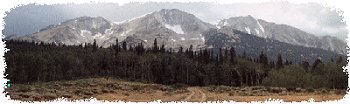
I am always amazed to learn of a new hike, place, or mountain that I have never heard of before - especially one so close to my home in Denver. Nestled behind Mount Evans, Gray Wolf Mountain is such a hike.

The Hells Hole trailhead.
To reach the trailhead to Gray Wolf Mountain, head south on the Mount Evans Highway out of Idaho Springs. About seven miles outside of town, Mount Evans Highway makes its first major switchback to the left and FR 188 (Forest Service Road) turns off to your right (southwest). Follow FR 188 (all wather gravel) about another two and a half miles up the West Chicago Creek watershed until you reach the Hells Hole trailhead just beyond the campground.
This hike was suggested to me by a friend who had recently been in the area but turned around due to excessive snow and lack of time. I had made a quick glance over my maps of the area before heading out but did not really know what to expect.
The trail starts out with a gradual climb first through Aspen trees which later gave way to a somewhat dense cover of conifers as it switched back and forth to get on top of a ridge which segmented the valley. Not noticing a Wilderness sign back near the trailhead, I was somewhat surprised to find it a half mile or more into the hike. The trail continued to gain on the ridge and after about two miles of hiking, the valley opened up before my eyes.

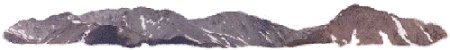
Gray Wolf Mountain
Ahead of me I could see Gray Wolf Mountain which appeared to be remotely connected to Sugarloaf Peak by a long ridge covering more than a mile. Not knowing if my plan to reach Gray Wolf were feasable, I thought to myself, if I can't get to Gray Wolf, at least I'll be able to snag Sugarloaf by walking along the ridge. I continued to follow the trail up the valley, all the while scouting for a shortcut up to the top of the ridge, but the trail never quite seemed to reach treeline. Eventually, I thought I spied my route to the top.

Looking back down the valley from up on the ridge.
To get where I wanted to go, I ended up leaving the trail to scramble down a short slope to cross a fork of West Chicago Creek at a point where a snowbridge made my crossing relatively easy. Upon crossing the creek, my journey would take me up along a ridge which separated the relatively gentle valley which contained the trail from a valley which looked about as accessable as the moon! I would later discover that I was about to completely circumvent this rugged, yet extremely beautiful valley. The ridge that I was now on was really the first serious elevation gain since begining this trip.

The rocky terrain on the way to the top...
While climbing this ridge, to my left was the rugged valley, to my right was a wide gentle slope, and in front of me were rocks - lots of rocks. From below, it appeared as though would be able to cirumvent the highest point along the traversing ridge by going to the left but once there, I found out that there was no left - only a drop-off of several hundred feet. This commited me to continuing to the highest point where I was to discover what would be my route to the summit.
The rugged valley went back much further than it appeared from any point lower in the valley. My trek was now going to be a long, relatively flat, circuitous route around the head of the valley followed by a short climb to the summit. I rested at this preliminary high point for a few minutes while hiding behind some rocks to take a brief sabbatical from the constantly blowing strong winds. From this first high point, I was now able to scope out my surroundings. Guanella Pass was just to my West, Mount Evans and Mount Bierstadt were just to my south.

... almost to the top ...
Knowing that my view would be even better from the summit of Gray Wolf, I headed out for the second leg of my hike. I traversed the long circuitous route and found myslef at the base of a long gentle slope which would take me to the top. As I was now in the 13,000 foot elevation range, I took frequent breaks while traversing to avoid a smattering of the remnants of last seasons' snow.Eventually I found the ground had pretty much leveled off although I was still several hundred yards from the summit. These last few steps were pretty easy but by now I had to keep my eye on the weather as storm clouds were developing in the mountains around me.

Mount Evans from the summit of Gray Wolf Mountain.
From the top of Gray Wolf Mountain (elev. 13,602), Grays and Torries Peaks were visible to my immediate west. Below them was Square Top Mountain with Guanella Pass below that.
 to/from the summit of Gray Wolf Mountain.")
The long circuitious traverse (center left) to/from the summit of Gray Wolf Mountain.
Much further to the west, I could make out the cross on Mount of the Holy Cross - many miles away and barely visible on the horizon. Again, to the south was Mount Bierstadt, Mount Evans, and South Park even further beyond. To the east, I could make out Denver and the greater metropolitan area. To the north I could see much of Arapaho National Forest although I didn't make an effort to identify any of these peaks or any of the other peaks visible off to the northwest.
As I was still keeping an eye on the weather, I only spent 15 minutes on the summit. I took the time to sign the register and noticed that I was only the fifth person on this summit since March 5th of this year. I took some of the photos that you see here, and spent the rest of the time enjoying the views and trying to stay out of the wind by hiding behind the rock carin marking the summit.

... my way down from the top ...
I had already invested a major portion of my day getting to this point and was hoping to find a quicker way back down to the trail (rather than retracing my steps around the head of the rugged valley). I decided that I would commit to descending the ridge that I had scouted earlier in the day, hoping that I could find a way through the trees to once again reach the West Chicago Creek valley.
Descending this ridge was fairly easy. It wasn't too steep but it was rocky. I was by now in somewhat of a hurry as I could see a snowstorm forming over Grays and Torreys to my west but not so much in a hurry that I couldn't take another time out to admire the scenery or take photos.

... the ridge which was my way back down ...
As I descended this ridge, something caught my eye way off in the meadow below me. Somehow I was able to see off in the distance two elk enjoying the afternoon in the meadow at treeline. One was lounging (laying down) and the other was grazing on the early spring grass. I was curious as to just how close I could get to the elk - for photo purposes of course. I didn't want to stress them to any extent as their life is difficult as is. At first I made no significant effort to hide my presence however after the grazing elk raised it's head showing me that he knew I was in their neighborhood, I became a little more secretive - even though I was still probably several hundred yards away. I was able to sneak about 50 yards closer while hiding behind a roll on the slope. I had forgotten about the weather situation as these elk now captured my attention.

The meadow containing elk.
I was now close enough to make out the fact that these were two bulls - their antlers still in velvet. By now, they knew I was there and I needed to continue on my way. I attempted to traverse above them without disturbing them any further however they apparently didn't like my presence and sought the refuge of the trees below.
Now the elk were no longer my main concern - I needed to get back to the trail. I now had to bushwhack down through the trees to get back to the valley (on my left) without ending up on top of the cliffs which were easily visible on my way up earlier in the morning. I traversed down valley as I descended but at one time found myself to say out loud "This isn't good." I hadn't traversed far enough to the north before descending and now had to do a hard traverse to keep from going over a cliff.
 in this photo?")
Can you see the two bull elk (center and center left) in this photo?
Eventually I found a way around the cliffs and heard the sound of water. By now I have spent enough time in the mountains to know that noisy water has the potential to be narrow while silent water can be wide. I knew that to reach the trail, I would have to cross the creek, therefore I headed for where I could hear the water. Upon coming out of the trees at the bottom of the valley, I was luck to find myself at a point where the creek was definitely cross-able, although not easily. I scouted about a hundred feet of the creek only to find the narrowest point was a good 6 feet wide without a good takeoff or landing point for jumping. It was then that I decided that it might actually feel good to take my shoes off to wade the stream which was only about a foot deep where I crossed. Once on the other side, I decided to take another break to let my feet air dry and to enjoy my last moments (or so I thought) in the mountains for the day. After a brief rest, I noticed that where I was looked like quite the watering hole for the local wildlife (due to the many tracks in the mud in the area), and as it was by now getting to be late afternoon I thought that it was time to give the animals back their turf.

What a view ...
By now, all I knew was that the trail was above me to the west. Would I have to climb 100 feet or 500 feet to reach the trail. The truth was closer to the latter. Exhausted, I bush-whacked my way up, through trees, brush, and over boulders. Finally, on top of the ridge I once again found the trail and felt as though I were almost home. The truth was that I still had about a two mile hike ahead of me before reaching the trailhead and my car.
On the way back out, I passed several backpackers coming in for a quick little Saturday night overnight in the backcountry. The most interesting qroup that I passed included about a dozen big guys that were determined to party. I say this because not only were they carrying their camping gear but also a quarter-barrel of beer, lots of ice, and a tub to keep it in. I guess these are the tradeoffs when you hike so close to town, but overall, I didn't encounter another living person and was able to enjoy complete solitude for the majority of the day. |
Along on this hike with me: no one.